Search engine for geological maps (FID GEO)
The interactive overview map on GEO-LEOe-docs provides access to the online freely available sheets of the geological maps GK25 and GK50. Map sheets already available on GEO-LEOe-docs are listed, usually complemented with the associated explanatory booklets. Researchers may propose public domain map sheets of the GK25 for digitization by the FID GEO free of charge.
Search engine for topographic maps (SIS Maps)
Our partner, the Specialised Information Service for Cartography and Geodata (SIS Maps), offers various map catalogues on its website, including a high volume of topographic map series with links to the world's national and regional geoportals as well as links to various country-specific Grids&Datums.
Search alphabetically by country name under: Topo-List.
GEO-LEOe-docs is the geoscientific repository for texts and geological maps, maintained by the FID GEO and operated at the Göttingen State and University Library (SUB Göttingen). GEO-LEOe-docs serves as a platform for Green Open Access publications (secondary publications). It also offers an interactive overview map with access to digitised geological maps (GK25). On GEO-LEOe-docs all documents are freely accessible and referenced with DOI. Various ongoing net publications are released here as digital first publications.

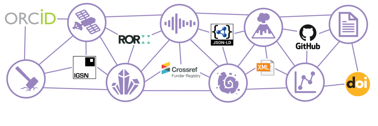
GFZ Data Services is the subject-specific research data repository for the geosciences and related disciplines, through which research data have been published with DOI since 2004. Today, GFZ Data Services is an internationally recognized repository for citable and DOI referenced geoscientific data, software and the assignment of International Generic Sample Numbers (IGSN = PID for physical samples).
News
NFDI4Earth attends the NFDI Conference in Bonn
NFDI4Earth attended the first National Research Data Infrastructure (NFDI) conference organized by the DFG on 13/14. May 2019 in Bonn, thereby securing participation in the NFDI tendering procedure.
In order to be able to participate in the NFDI conference, a short project description in the form of an “extended abstract” was submitted to the DFG, which succinctly presents the basic ideas, background and goals of the project. Prof. Monika Sester, Prof. Lars Bernard and Roland Bertelmann introduced the planned NFDI4Earth consortium with a short presentation and a poster at the conference. Presentation slides and poster are linked on the NDFI4Earth website.
“The two-day meeting was endorsed by all participants as consistently positive,” writes the DFG in its detailed press release on the conference.